Important Lines and Boundaries of the World. | List of International Boundary Lines PDF
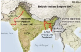
Radcliffe Partition Line
This boundary line is between India and Pakistan drawn by Sir Cyril Radcliffe in 1947.Its border line length is 3323 Kms. But border length of India with Purbachal (operating zero line) is 4096.7 Kms.
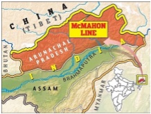
McMahon Line
The boundary line between India and China to which China does not approve. It was demarcated by Sir Henry McMahon. Its borer length is 3380 Kms.
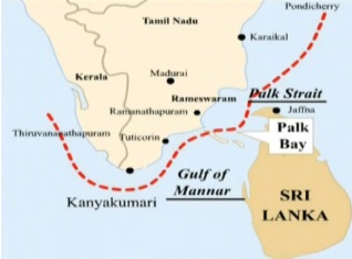
Palk Strait
Palk Strait is a water body separating India from Pakistan. Its border length is 30 Kms.
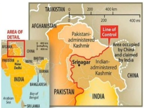
Line of Control (LoC)
The term Line of Control (LoC) refers to the military control line between the India (state of Jammu and Kashmir) and Pakistan. A line which does not constitute a legally recognized international boundary, but is the de facto border. It was redesigned as the “Line of Control” following the Shimla Agreement, which was signed on 3 July 1972.
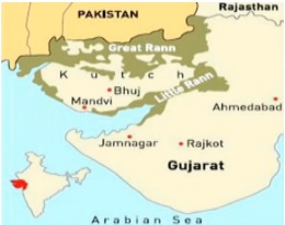
24th Parallel
Line which claimed by Pakistan for demarcation between India and Pakistan in great Rann of Kutch but India do not recognize it.
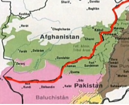
Durand Line
International border between Pakistan and Afghanistan. It was established in 1896 by Sir Mortimer Durand.Its border length is 106 Km.
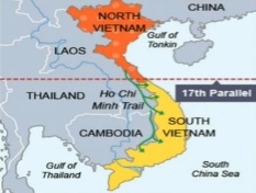
17th Parallel
The line which defines the boundary between North Vietnam and South Vietnam before the two were united. It was designed in 2nd July 1976.
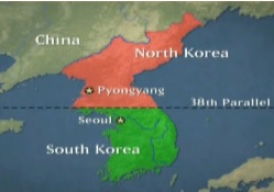
38th Parallel
The boundary line between North Korea and South Korea. It is also known as Demilitarized Zone (DMZ). Sometimes, it is also indicated as the most dangerous of the world.
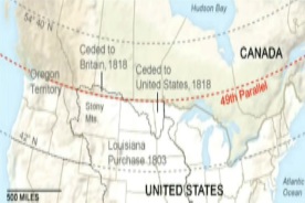
49th Parallel
It is the boundary line between the United State of America and Canada. This is the longest official international border
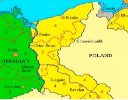
Oder-Neisse Line
The boundary line between Poland and Germany (it was named after Oder and Neisse rivers). It was demarcated after World War II at Potsdam Conference.
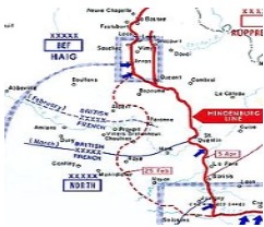
Hindenburg Line
Boundary line between Germany and Poland to which German retreated in March 1917 during the First World War. This operation is also known as Alberich.
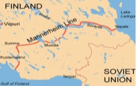
Mannerheim Line
The boundary line is between Russia and Finland.
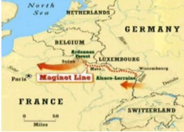
Maginot Line
The boundary line is between France and Germany.
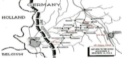
Siegfrid Line
The boundary line is between France and Germany.Its name was kept after Andre Maginot who was the French Minister of of War in 1930 (World War I). It is also known as Westwall.
20th Parallel Line
The line which Pakistan claims should be Demarcation line between India and Pakistan, not accepted by India.
20th Parallel North
Boundary line between Libya and Sudan.
22nd Parallel North
Boundary line between Egypt and Sudan.
35th Parallel North
It forms the boundary between the state of North Carolia and the state of of Geoegia, the State of Tannessee and the State of Georgia, the State of Alabama.
33rd Parallel North
It cuts through the southern United States, parts of North Africa, parts of the Middle East and China.
37th Parallel North
It formed the southern boundary of the historic and extralegal Territory of Jefferson.
39th Parallel North
It is an imaginary circle of latitude that is 39 degree north of the Earth’s equatorial plane.
40th Parallel north
It is the boundary of the British Colony of Maryland.
41th Parallel north
It is the boundary between Nebraska and Wyoming and the southern boundary of Wyoming with Colorado and Utah.
42nd Parallel north
It is at the New York – Pennsylvanian Border.
43rd Parallel north
It lies between the State of Nebraska and the State of South Dakota.
The Parallel 440 north
It is 44 degrees north of the equatorial plane.
45th Parallel north
It also called the halfway point between the Equator and the North Pole.
45th parallel
It is the boundary between Wyoming and Montana.
Marginal Line
It is 320 km line of fortification built by France along its border with Germany before World War II, to protect its boundary from German attack.
Mason-Dixon
It is a line of demarcation between four states in the United States.
Curzon Line
The Curzon Line is an international boundary drawn between the Second Polish Republic and Soviet Union. It was demarcated by a British historian Lewis Namier in 1919.
Wagah Border
It is also a border between India and Pakistan. It is situated in Wagah village located in Lahore District, Punjab, Pakistan and lies near Radcliffe Line. The Wagah border is located 24 km from Lahore and 32 km from Amritsar, India.
Mexico-USA Border
It is an international boundary of 3200 kms long extends from Pacific ocean to Gulf of Mexico separates United States from Mexico.
Argentina-Chile Border
It is the longest land border of South America with a length of 5150 kms. The border divides Argentina from chile with Andes mountains and on the islands of Tierra del Fuego.
Teen Bigha Corridor
India and Bangladesh have handed over sovereignty of a land ‘Tin Bigha Corridor’ to each other according to the treaty signed in 16 May 1974 between Indira Gandhi and Sheikh Mujibar Rahaman. It is one and only land border between India and Bangladesh. Benapole is the border crossing of Bangladesh to India and Petrapole is the border crossing of India to Bangladesh.
| Border Country With India | Border Line Names of India | Border Line Length |
| Myanmar | Indo-Burma Barrier | 1643 Km |
| Nepal | indo-Nepal | 1236 Km |
| Bhutan | Indo-Bhutan | 699 Km |
| Afganisthan | Durand Line | 106 Km |
| Pakistan | Radcliffe Line | 3323 km |
| Bangladesh | Purbachal (operating zero line) | 4096.7 Km |
| China | McMahon Line | 3380 km |
| Srilanka | Palk Strait | 30 Km |
International Boundary Lines of India PDF
Aspirants can download International Boundaries Lines of India PDF by clicking on below link.
All the best for your upcoming exam!
You can join or visit at Facebook Page or Twitter for always keep in touch with further updates.
Read more articles….